Last edited by HigherLove on Sun Feb 19, 2012 12:10 pm; edited 21 times in total

~ The only Home on the Web You'll ever need ~


LeeEllisMusic wrote:Something is going on in your neck of the woods, my friend~
Not sure what this means, but had to pass it on -
Are you close to this???


HigherLove wrote:While other companies profit and put their names out there, Pacific Gas and Electric (PG&E) controls the distribution. They control the meters. Just a taste of what they are capable of doing. Oh - it was announced today that they would be hiking up gas rates. I wonder if this has to do with offsetting damages from the San Bruno explosion?<iframe title="YouTube video player" width="640" height="510" src="https://www.youtube.com/embed/pAnjbp2c5KU" frameborder="0" allowfullscreen></iframe>
HigherLove wrote:Water for the Old Faithful Geyser of California comes from an underground river. When this water flows over the hot molten magma deep in the earth, it boils and expands and is collected in large cavities. Under tremendous pressure from the heat, and assisted by a constriction of the passage upward, the superheated water is forced through the fissures and fractures and erupts with an outpouring of steam followed by a fulmination of hot dancing water.
Under normal conditions, the water, the heat and the underground structure all remain constant and for this reason Old Faithful erupts regularly. Conditions which cause deviations from the normal pattern seem to relate to earthquakes. The Old Faithful Geyser of California is proving itself a predictor of quakes.
Earthquakes
From two days to two weeks prior to an earthquake, the Old Faithful Geyser of California gives warning by delaying its regular performance from the average thirty minutes to a longer interval. During this prolonged interval, it may send up "splits," small eruptions to no more than two or three feet in height, every few minutes. Finally, after the long delay, a 60-foot column of water and steam shoots upward.
The Geyser will return to its normal pattern unless interrupted by further tectonic stresses. Several scientists have studied the Geyser and one scientist has set up an infrared heat detector nearby. When the Geyser erupts, the detector is activated and information is relayed into an office where a taped printout automatically records all the eruptions day and night. The scientists then can use such information to determine whether or not Old Faithful's digressions from normal behavior correlate with the advent of an earthquake, and records are kept for future comparisons. The earthquake activity is not located at the Geyser, but within 500 miles or more from the area.
A scientific study sponsored by the Carnegie Institution of Washington DC, is being conducted in order to document the possible correlation between the Geyser eruptions and earthquake activity.
http://www.oldfaithfulgeyser.com/information.html
___________
Geysers and the Earth's Plumbing Systems
Introduction
Geysers are essentially hot springs that become thermodynamically and hydrodynamically unstable. However, geysers are extremely rare on the surface of the earth, indicating that a complex set of parameters must be exactly right for geysers to occur. Figure 1 shows locations and Table 1 lists names of geyser fields of the world. It is worth noting that there are only approximately fifty geyser fields known to exist on earth and around two-thirds of those fifty contain five or fewer active geysers. Yellowstone National Park in Wyoming, U.S.A. has, by nearly an order of magnitude, more geysers than any other field known, and has been the site of extensive study of the properties and characteristics of geysers.
Because geysers are so rare, there have been several investigations into the conditions that must exist for geyser activity. It has been found that at least three essential conditions must be met, but there are many other contributing factors that influence the type and frequency of eruptions. The basic elements of a geyser are: 1) a water supply, 2) a heat source, and 3) a reservoir and associated plumbing system (Figure 2).
http://www.umich.edu/~gs265/geysers.html
There is a generally a strong correlation between earthquake activity and geyser behavior. This phenomena has been observed for centuries, but only recently have the changes in geyser behavior been documented. The 1959 Hegben Lake earthquake has had the most dramatic effect on Yellowstone geysers of any earthquake since the park's discovery (Rhinehart, 1980). Since the epicenter was so close to Yellowstone (only about 50 km away) the effects were significant. Immediately after the earthquake, all the geysers in the park erupted, and the average temperature in geysers and springs increased by an average of 2°C. Some geysers that were previously dormant became active, ostensibly by the opening of sealed channels along planes of weakness, and several active geysers changed their eruptive behavior. However, geyser response to earthquakes seems somewhat variable. Old Faithful in Yellowstone was the only geyser in the park that did not change its eruptive behavior after the Hegben Lake earthquake (Rhinehart, 1980). However, it has responded to several other earthquakes with epicenters much farther away, such as the magnitude 8.4 earthquake in Alaska in 1964. This indicates that the profound changes in geyser activity due to earthquakes are not due to slip along faults so much as by changes in regional strain. Since geysers record earthquake activity in a reasonably consistent manner, there have been several studies on whether geysers could be used as predictors for earthquake activity. Rhinehart (1980) states that in his detailed studies of geysers, there have been no systematic correlations between earthquakes and geyser activity. A more recent study by Silver and Valette-Silver (1992) showed that some geysers in California show changes in observable activity before nearby earthquake activity. They surmise that, although the response of geysers to tectonic strain is not well understood, there are two basic mechanisms by which seismic activity could affect geyser behavior. In the first, changes in the regional strain field change the volumetric flow velocity into the reservoir, thus affecting the interval between geyser eruptions. In another scenario, the permeability of the plumbing system could change due to strain-induced changes in microfractures in the geyser reservoir.
____________________________________________
Note: Calistoga is near the "Geysers". When people refer to the geysers around here, it is what we used to call "steam wells", back in the late 70s/early 80s.
This information placed because the two locations are essentially the same.


HigherLove wrote:Quakes? Town points finger at a nearby steam project
Nature has been eclipsed by human factors, say rural residents
Anderson Springs -- A surge in the number and severity of earthquakes near the Geysers, the world's largest geothermal development, has alarmed rural neighbors and they're not blaming Mother Nature.
"These aren't natural earthquakes," said resident Connie Dethlefson, one of many citizens in this tiny community who insist that the temblor problem is a man-made byproduct of nearby steam-power production facilities.
Since 1960, "induced seismicity" has been a chronic occurrence in the area, even according to geologists at Calpine Corp., the San Jose power company that now owns most of the two dozen power plants in a 30-square mile area along the Sonoma and Lake county line. The facilities, built on ridgetops to stay clear of landslides, draw steam from underground reservoirs.
But the controversy here turns on an apparent recent increase in shakers. In May alone, three quakes were recorded in the Geysers area: a 3.7 magnitude on May 3, a 4.0 on May 20 and a 3.4 on May 21.
Some people in Anderson Springs seem convinced that earthquakes now threaten to wreck their community's very foundations. And they believe huge injections of water, pumped deep underground at the Geysers in order to replenish the steamfields that drive the turbines, are causing the temblors.
In 1997, communities around Clear Lake began diverting millions of gallons of treated wastewater daily to the Geysers through a 29-mile pipeline project.
The pipeline is currently delivering 7.5 million gallons a day. Another 11 million gallons are due to start arriving daily from Santa Rosa later this year, although that will be delivered to a different part of the steamfields farther from Anderson Springs. Final testing of the Santa Rosa pipeline project is under way.
The idea was to provide clean energy and give the communities a handy outlet for wastewater that otherwise could add to pollution problems of sensitive watersheds.
But while environmentalists have applauded the projects, the talk in Anderson Springs lately has focused on widening cracks in old stone foundations, falling knickknacks and frazzled nerves.
"We're rockin' and rollin' all the time," said Meriel Medrano, the local water-district manager, who has had a house in Anderson Springs since 1969.
Stones keep popping out of her chimney, she said, and a vase toppled in the May 3 temblor -- one of the latest and largest quakes among hundreds that have been recorded in or near the Geysers in recent years.
"The earthquakes have been increasing astronomically," she said.
Seismic monitoring sponsored by the power companies began in the late 1960s,
bolstered in 1979 by an array of monitors installed by the U.S. Geological Survey. The data show a clear increase in the frequency of small earthquakes, and there's not much debate about the link to steam-driven energy production.
"There's no question, absolutely no question, that almost all the earthquakes are related to activities related to power production," said David Oppenheimer, a geophysicist at the USGS.
The question is whether the induced quakes are mere annoyances. Industry experts claim the quakes are almost all too small even to be felt, let alone cause any significant damage.
"An increase was anticipated in terms of these micro-earthquakes," said Dennis Gilles, a Calpine vice president for the Geysers operations. "But you get a magnitude 2 earthquake, and it's not even like a truck driving by."
But the picture starts getting a little murky when it comes to bigger quakes, those above magnitude 2.5 or so, according to Bill Smith, a senior geologist at the Northern California Power Agency, a collection of public power authorities that also operates at the Geysers.
Smith said there is no clear evidence that the Geysers are causing anyone harm, despite some increase in low-level shakings.
"We don't experience any damage here," Smith said, "not even within our own offices, and we're sitting right on top of the Geysers."
Anderson Springs residents want special monitoring. But Mark Dellinger, special districts manager for Lake County and chairman of a seismic-monitoring committee set up as part of the county's pipeline project, said a "huge investment" has already been made to keep tabs on every move the ground might make in the Geysers area.
It's been enough, he said, to make tiny Anderson Springs, which lacks even a post office or a single commercial establishment, a unique laboratory for seismic research in a geothermal area.
"I doubt there is a community anywhere in the world this small with this kind of sophisticated seismic array," Dellinger said. "I don't think there's any conclusive evidence to support any of the claims being made."
By all accounts, it will take more monitoring to determine just how serious the problem is and what might be making it worse.
The issue is complicated by such factors as local geology and faulting, frequent changes in levels of power production, and even by local construction styles in a hilly, landslide-prone area full of old homes that started as summer cottages.
The recent increase is mostly in small, shallow quakes. This could prove to be just some natural variability, an anomaly perhaps due to subside on its own.
If the root cause of the shaking turns out to be depletion of the steam reservoirs, then the additional water being injected might eventually help to reduce disturbances.
Another leading theory is that the increased seismic activity results from rapid cooling and fracturing of rocks deep underground where temperatures are normally about 450 degrees Fahrenheit. If so, problems could be worsened by the injection of millions of gallons of 50 or 60 degree wastewater from the surface.
All this does little to reassure folks in Anderson Springs.
Residents described being jolted out of bed at night by brief but sharp explosions underground, seemingly more violent all the time, sometimes hitting a house as if by a truck ramming into the front porch.
Jacqueline Felber said she and her husband had to replace 60 cracked ceramic tiles in their kitchen, where the floor lately has become noticeably bowed. Walking around outside, she pointed out some gaps in the siding, which she said have been spreading ominously of late.
After 17 years in Anderson Springs, Felber insisted that she and her artist- blacksmith husband still love their place. Still, she said, "You can see where it's starting to come apart at the seams."
No injuries have been reported. The biggest alleged casualty, however, may have been an old black oak tree that toppled across one of the creeks trickling through the unincorporated town, where bone-weary celebrities once visited to take the local waters. But no one can prove whether it was an earthquake, or perhaps a strong gust of wind, that brought it down.
Jeff Gospe, a Santa Rosa business consultant whose in-laws own a home in Anderson Springs, was adamant that local quake damage is real and getting worse, exacerbated by the wastewater projects and increased steam-power production.
"It's only a matter of time before someone gets hurt," he said.
Gospe, 35, serves as president of the recently formed Anderson Springs Community Alliance. The organization demands that the power plant companies and public agencies behind the pipeline projects create regulatory and insurance mechanisms to protect landowners and local taxpayers.
Gospe produced an armful of gigantic geology maps and a 4-inch-thick binder full of survey results, photographs and color charts showing earthquake trends.
His central conclusion, based on public data and later confirmed by Oppenheimer as essentially valid, is that something on the order of 1,900 earthquakes of magnitude 2.0 or larger have occurred within a 5-mile radius of Anderson Springs since 1970.
"They used to be just little shakers," said Alan Kuykendall, a condominium manager in Napa who spends about half his time at a home he bought in Anderson Springs in 1980. "The earthquakes are much worse now than they ever were."
http://www.andersonsprings.org/NewsArticles/8june2003sfchronicle.html
http://www.abovetopsecret.com/forum/thread426897/pg1
http://www.andersonsprings.org/NewsArticles/pressdemocratneighborsworriedaboutquakes28jun2009.pdf
http://www.altarockenergy.com/
HigherLove wrote:thanks mudra!<iframe width="560" height="349" src="https://www.youtube.com/embed/O0fT1U-6zUs" frameborder="0" allowfullscreen></iframe>
The Cascadia Subduction Zone goes from Cape Mendocino, California to northern Vancouver Island.
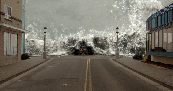
Megathrust earthquakes occur at "subduction zones" which are the collision points between tectonic plates. Generally a huge slab of the ocean floor is forced underneath a continental plate. At magnitude 9 and higher, these are among the world's largest earthquakes. If this crack in the ocean floor rips apart in a vertical direction, it can lift a mountain of seawater (sometimes several kilometers deep), generating a series of enormous tsunami waves.
The crack in the sea floor off Sumatra, where the devastating tsunami of December 26, 2004 occurred, is 1400 km long. This is almost exactly the same length (and it also has approximately the same width) as the Cascadia Subduction Zone.
City streets from Vancouver to Sacramento will be littered with glass and debris from a magnitude 9 earthquake in the Cascadia Subduction Zone.
A megathrust earthquake at a magnitude of 9 or higher is highly likely for the cities of Sacramento, Portland, Seattle, Vancouver and Victoria plus hundreds of smaller towns from California to British Columbia. (Estimates of the Sumatra-Andaman Earthquake of 2004 are between 9.1 and 9.3.)
Megathrust earthquakes can create 15-metre tsunami waves, which could hit the beaches on the West Coast in 20 minutes or less (just as they did in Sumatra). In a few local zones the Sumatra waves were as high as 30 metres (approximately 100 feet), and the same kinds of waves are expected from the Cascadia Subduction Zone.
Marine Geologist Chris Goldfinger from Oregon State University shows viewers mud core samples that document 39 Cascadia fault ruptures over the past 10,000 years. 19 of those were full margin ruptures (magnitude 9 or higher) along the entire length of the subduction zone. Some of the quakes were 800 years apart, others only 200 years apart. The last full-margin megathrust earthquake happened more than 300 years ago - on the night of January 26th, 1700.
Tsunami waves 15 to 30 metres high will inundate coastal communities from California to British Columbia only 20 minutes after a magnitude 9 earthquake. Shown here is what the first wave in Seaside, Oregon may look like. Photo Credit: Artifex Studios
http://www.cbc.ca/documentaries/doczone/2009/shockwave/factsheet.html
HigherLove wrote:Welcome to the Fluids and Magmas EarthScope Thematic Working Group Community Pages. Non-registered visitors are allowed to view all entries, information, and comments submitted by registered members. Those wishing to join one or more TWG can utilize the 'Register' link at the top right to register as a member of this online community. Only registered members are allowed to post articles, information, and/or comments on articles submitted by other registered members.
http://www.earthscope.org/twg/fluids_magmas_entry/fluids_and_magmas_national_meeting_summary_report
http://science.kqed.org/quest/2011/04/28/bay-area-volcanoes/
http://www.rumormillnews.com/cgi-bin/archive.cgi?noframes;read=198086
They look like a good start in the quest for the rest. Nice one HL.
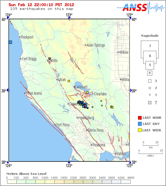
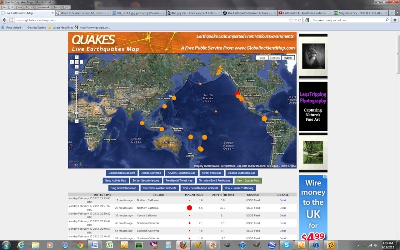
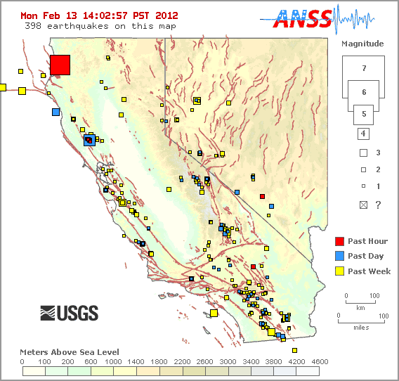
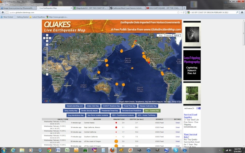
HigherLove wrote:We just got hit a bit ago. Again, this is not good. Damage in Anderson Springs is likely. It will take a few days to know, as the local paper does not come out until Tuesday.
Magnitude 4.3
Date-Time
Monday, February 13, 2012 at 04:47:12 UTC
Sunday, February 12, 2012 at 08:47:12 PM at epicenter
Time of Earthquake in other Time Zones
Location 38.790°N, 122.745°W
Depth 0.4 km (~0.2 mile)
Region NORTHERN CALIFORNIA
Distances
5 km (3 miles) E (100°) from The Geysers, CA
5 km (3 miles) SSW (202°) from Cobb, CA
5 km (3 miles) WNW (290°) from Anderson Springs, CA
24 km (15 miles) E (92°) from Cloverdale, CA
38 km (24 miles) N (355°) from Santa Rosa, CA
114 km (71 miles) WNW (284°) from Sacramento, CA
Location Uncertainty horizontal +/- 0.1 km (0.1 miles); depth +/- 0.2 km (0.1 miles)
Parameters Nph= 71, Dmin=1 km, Rmss=0.09 sec, Gp= 43°,
M-type=regional moment magnitude (Mw), Version=7
Source
California Integrated Seismic Net:
USGS Caltech CGS UCB UCSD UNR
Event ID nc71729135
Earlier today, in my sister county:
Magnitude 3.3
Date-Time
Sunday, February 12, 2012 at 22:32:59 UTC
Sunday, February 12, 2012 at 02:32:59 PM at epicenter
Time of Earthquake in other Time Zones
Location 39.675°N, 123.973°W
Depth 0.1 km (~0.1 mile) (poorly constrained)
Region OFFSHORE NORTHERN CALIFORNIA
Distances
14 km (8 miles) WSW (245°) from Cape Vizcaino, CA
15 km (10 miles) WSW (242°) from Rockport, CA
30 km (18 miles) NNW (331°) from Fort Bragg, CA
88 km (55 miles) NW (312°) from Ukiah, CA
249 km (155 miles) WNW (301°) from Sacramento, CA
Location Uncertainty horizontal +/- 1.1 km (0.7 miles); depth +/- 3.3 km (2.1 miles)
Parameters Nph= 35, Dmin=34 km, Rmss=0.4 sec, Gp=180°,
M-type=local magnitude (ML), Version=3
Source
California Integrated Seismic Net:
USGS Caltech CGS UCB UCSD UNR
Event ID nc71728955
______________________________
1.2 2012/02/12 21:18:42 38.762N 122.740W 2.2 4 km ( 3 mi) WSW of Anderson Springs, CA
1.2 2012/02/12 21:17:59 38.762N 122.741W 2.3 5 km ( 3 mi) WSW of Anderson Springs, CA
1.4 2012/02/12 21:15:45 38.762N 122.742W 2.1 5 km ( 3 mi) WSW of Anderson Springs, CA
1.0 2012/02/12 21:11:42 38.792N 122.749W 2.0 5 km ( 3 mi) E of The Geysers, CA
1.2 2012/02/12 20:57:41 38.819N 122.768W 0.0 4 km ( 3 mi) NE of The Geysers, CA
2.6 2012/02/12 20:55:25 38.785N 122.735W 1.6 4 km ( 2 mi) WNW of Anderson Springs, CA
1.0 2012/02/12 20:54:39 38.842N 122.772W 1.3 4 km ( 3 mi) W of Cobb, CA
1.9 2012/02/12 20:51:47 38.801N 122.743W 0.4 4 km ( 3 mi) SSW of Cobb, CA
1.9 2012/02/12 20:51:30 38.793N 122.728W 0.0 4 km ( 2 mi) WNW of Anderson Springs, CA
1.0 2012/02/12 20:50:28 38.800N 122.747W 0.8 4 km ( 3 mi) SSW of Cobb, CA
1.9 2012/02/12 20:49:07 38.793N 122.772W 3.9 3 km ( 2 mi) E of The Geysers, CA
4.3 2012/02/12 20:47:12 38.790N 122.745W 0.4 5 km ( 3 mi) WNW of Anderson Springs, CA
1.2 2012/02/12 18:17:28 38.833N 122.792W 2.4 4 km ( 3 mi) NNE of The Geysers, CA
3.3 2012/02/12 14:32:59 39.675N 123.973W 0.1 14 km ( 8 mi) WSW of Cape Vizcaino, CA
1.1 2012/02/12 13:41:40 38.808N 122.810W 2.7 1 km ( 1 mi) NNW of The Geysers, CA
1.0 2012/02/12 12:34:29 38.751N 122.692W 1.4 3 km ( 2 mi) S of Anderson Springs, CA
1.0 2012/02/12 12:14:04 38.828N 122.854W 2.1 5 km ( 3 mi) NW of The Geysers, CA
1.8 2012/02/12 05:56:39 38.831N 122.806W 2.0 4 km ( 2 mi) N of The Geysers, CA
1.8 2012/02/12 04:56:13 38.802N 122.789W 3.6 2 km ( 1 mi) ENE of The Geysers, CA
1.4 2012/02/12 04:42:12 38.833N 122.774W 2.8 4 km ( 3 mi) W of Cobb, CA
1.3 2012/02/12 03:46:57 38.843N 122.838W 2.4 6 km ( 3 mi) NNW of The Geysers, CA
1.1 2012/02/12 03:34:46 38.840N 122.841W 2.1 5 km ( 3 mi) NNW of The Geysers, CA
1.4 2012/02/12 03:31:06 38.840N 122.839W 2.2 5 km ( 3 mi) NNW of The Geysers, CA
1.0 2012/02/12 03:19:59 38.842N 122.840W 1.9 6 km ( 3 mi) NNW of The Geysers, CA
1.4 2012/02/12 03:14:24 38.843N 122.828W 2.4 5 km ( 3 mi) NNW of The Geysers, CA
1.6 2012/02/12 03:02:20 38.808N 122.821W 2.1 2 km ( 1 mi) NW of The Geysers, CA
1.2 2012/02/12 01:46:01 38.837N 122.796W 2.4 4 km ( 3 mi) NNE of The Geysers, CA
1.5 2012/02/12 01:45:16 38.814N 122.818W 3.0 2 km ( 1 mi) NNW of The Geysers, CA
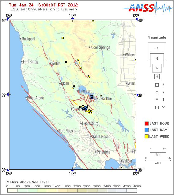
FROM JANUARY 24HigherLove wrote:RIGHT UNDER MY FEET AND I DID NOT FEEL IT I.E. THIS IS NOT A TYPICAL EVENT..........
Magnitude 3.8
Date-Time
Tuesday, January 24, 2012 at 12:11:28 UTC
Tuesday, January 24, 2012 at 04:11:28 AM at epicenter
Time of Earthquake in other Time Zones
Location 38.969°N, 122.693°W
Depth 3.1 km (1.9 miles)
Region NORTHERN CALIFORNIA
Distances
6 km (4 miles) SSW (200°) from Clearlake Oaks, CA
6 km (4 miles) WNW (289°) from Clearlake, CA
10 km (6 miles) NW (312°) from Lower Lake, CA
49 km (30 miles) ESE (114°) from Ukiah, CA
116 km (72 miles) WNW (294°) from Sacramento, CA
Location Uncertainty horizontal +/- 0.2 km (0.1 miles); depth +/- 0.6 km (0.4 miles)
Parameters Nph= 68, Dmin=4 km, Rmss=0.1 sec, Gp= 43°,
M-type=regional moment magnitude (Mw), Version=6
Source
California Integrated Seismic Net:
USGS Caltech CGS UCB UCSD UNR
Event ID nc71717085
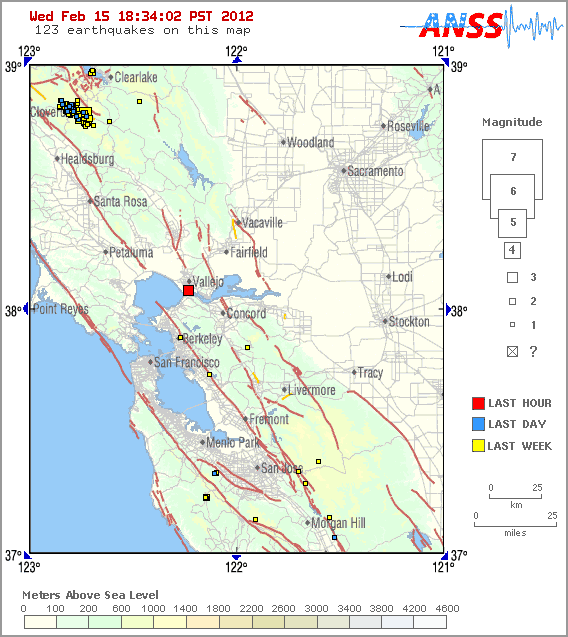
KNOCK KNOCK NEO..........................HigherLove wrote:UPDATE -
Just found the location. IN THE LAKE AT THE BASE OF THE VOLCANO, JUST A COUPLE OF MILES AROUND THE CORNER TO MY EAST...
It is the blue squares in the lake. As you can see, there have already been aftershocks.
The small cluster of quakes to the SW is The Geysers.
This is a really bad sign, folks. Not just for me.
So to be more accurate, the quake was in Kelseyville, California. Home of a living, breathing, freaked-out Druid and a volcano...
Mount Konocti (/kɵˈnɒktaɪ/) is a volcano in Lake County, California on the south shore of Clear Lake. At 4,305 feet (1,312 m), it is the second highest peak in the Clear Lake Volcanic Field, which consists of numerous volcanic domes and cones ranging from 10,000 to 2.1 million years old...
...The volcano is the most visible landmark in Lake County other than the lake. The mountain is located between the towns of Lakeport and Clearlake. It lies directly south of Soda Bay and Riviera Heights and east of Kelseyville. From the summit of Mount Konocti, the taller peaks and ridges around Snow Mountain can be seen to the northeast...
http://en.wikipedia.org/wiki/Mount_Konocti
I live a few miles away and did not feel it. It is quite rare. Go to Mists of avalon dot net for more: Search "California earthquakes". Screen name is HigherLove. Can search my posts for details on life in this area. There is also a "dormant" volcano, here.
DSummerMan 1 minute ago
@DSummerMan search for The Mists of Avalon. Search for: california-west-coast-seismic-activity-info-logs#68498
DSummerMan 1 second ago
@BabylonsKing Quakes here in the geysers can be manipulated by pumping treated water back in to the dry, hot rocks. They had to reduce input due to quakes, but not sure if this was related. We are experiencing M-class solar flares right now (magnetic storms = more quakes).
DSummerMan 1 second ago
A good shake. Friend on Facebook reports cracks in her walls. Our earthquakes here are often very shallow.
caliali1000 14 hours ago
https://www.youtube.com/watch?v=CmqQ5Z-_I90
HigherLove wrote:www.geo-energy.org
http://www.andersonsprings.org/
MAN-MADE GEOTHERMAL EARTHQUAKES
http://www.andersonsprings.org/Earthquakes.html
Earthquake Damage to Anderson Springs (these are "small" quakes, btw) -
http://www.andersonsprings.org/DamagePhotos1.html
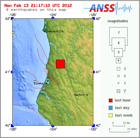
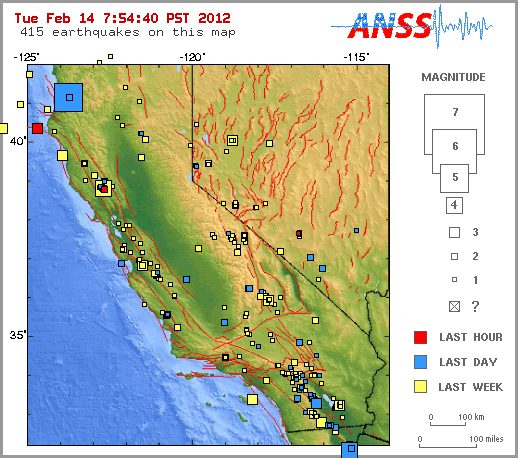
Magnitude 5.5
Date-Time
Monday, February 13, 2012 at 21:07:02 UTC
Monday, February 13, 2012 at 01:07:02 PM at epicenter
Location 41.153°N, 123.817°W
Depth 32.9 km (20.4 miles)
Region NORTHERN CALIFORNIA
Distances
10 km (6 miles) WSW (247°) from Weitchpec, CA
28 km (17 miles) ENE (63°) from Westhaven-Moonstone, CA
29 km (18 miles) ENE (70°) from Trinidad, CA
50 km (31 miles) NE (36°) from Eureka, CA
352 km (218 miles) NW (326°) from Sacramento, CA
Location Uncertainty horizontal +/- 0.3 km (0.2 miles); depth +/- 0.8 km (0.5 miles)
Parameters Nph= 62, Dmin=17 km, Rmss=0.17 sec, Gp= 72°,
M-type=regional moment magnitude (Mw), Version=5
Source
California Integrated Seismic Net:
USGS Caltech CGS UCB UCSD UNR
Event ID nc71734741
A moderate earthquake struck Northern California's coast Monday afternoon, rattling nerves around the Oregon border but yielding no immediate reports of major injury or damage, officials said.
The U.S. Geological Survey said the magnitude-5.6 quake struck at 1:07 p.m. about 18 miles east of Trinidad in an unincorporated part of Humboldt County. The epicenter is a rural area near the small community of Weitchpec, about 220 miles northwest of Sacramento.
The National Oceanic and Atmospheric Administration said the temblor was not large enough to generate a tsunami.
The Humboldt County Sheriff's Department and Eureka Police Department sent deputies and officers out to check on residents, but dispatchers said there was no immediate emergency reports.
"It was just a mild shaking. It wasn't a sharp jerk," said Sgt. Gene McManus of the Del Norte County Sheriff's Department, a neighboring agency that also saw no immediate emergencies.
Debbie Bailey, who owns an office supply store in Hoopa, about 5 miles from the epicenter, said only a few items fell off shelves there.
She described the jolt, which lasted four or five seconds, as "like a pick-up-and-move, like a soft wave."
"It didn't jar you, it was a gradual back and forth," she said.
Bailey said the local high school and elementary school in the Klamath Trinity district evacuated students as a precaution.
http://www.stltoday.com/news/national/magnitude--quake-strikes-northern-california/article_851a4d51-3f90-5c49-afe3-6f99c35f55b8.html#ixzz1mJMJJP3l
A 4.4 magnitude earthquake hit three miles from The Geysers in Sonoma County Sunday night, according to the USGS.
The Geysers is one of the most active areas of Northern California with small earthquakes hitting the area nearly every week. A 4.4 quake is on the large size for The Geysers. The UGSG Website says the largest quake ever to be recorded there was 4.5.
The U.S. Geological Survey said Sunday's 4.4 quake hit at 8:47 p.m. at a shallow depth of approximately 0.2 miles.
There were no reports of damage or injuries. People reported feeling the earthquake from San Francisco, Half Moon Bay and as far away as Santa Clara and Palo Alto.
Here is an explanation from the USGS as to why there are so many earthquakes in this particular area:
The Geysers geothermal field is located in a tectonically active region of Northern California. The major seismic hazards in the region are from large earthquakes occurring along regional faults that are located miles away from the geothermal field, such as the San Andreas and Healdsburg-Rodgers Creek faults. However, activities associated with the withdrawal of steam for producing electric power cause or induce small quakes to occur in the field. These smaller quakes are frequently felt by those who work at the field and by nearby residents.
Seismicity at The Geysers was poorly documented when power generation commenced in the 1960's, but since 1975 high-quality seismic monitoring data has been available, and it has been demonstrated that increased steam production and fluid injection correlates positively with changes in earthquake activity. The level of seismicity has been fairly stable since the mid-1980s, even though power production has declined in the field with the depletion of the steam reservoirs. Sheet 3 of Open-File Report 2002-209 illustrates how seismicity has spatially and temporally expanded with geothermal production.
Seismologists have proposed several mechanisms to explain why earthquakes are being induced. The operators of the geothermal field are withdrawing mass (steam boiled from water) and heat, both of which cause the surrounding rock to contract, which in turn can induce earthquakes as a result of the contractional stresses. In addition, the operators condense the extracted steam and flow the water back into the steam reservoir at depths of one to three km in order to extend the life of the field. Furthermore, reclaimed water from nearby Lake County and Santa Rosa is pumped to The Geysers and flowed into the steam reservoir. The condensed steam and reclaimed water is cold, whereas the rock is hot, and it appears that this thermal contrast is a significant factor in inducing the earthquakes. It is also possible that the hydraulic pressure of the injected fluid finds its way into faults and facilitates fracturing due to increased fluid pressures.
To date, the largest quake recorded at The Geysers is approximately M4.5. It is possible that a magnitude 5 could occur, but larger earthquakes are thought to be unlikely. In order for a larger earthquake to occur, it is necessary that a large fault exist. For example, the 1906 magnitude (M) 7.8 San Francisco earthquake ruptured nearly 300 miles of the San Andreas Fault. At The Geysers no such continuous fault is known to exist. Rather, there are numerous small fractures in the rock located near the many steam and injection wells. The activities described above result in local stress changes which, when added to the prevailing regional tectonic stresses, induce the quakes on these small faults.
http://www.nbcbayarea.com/news/local/44-Earthquake-Hits-The-Geysers-139199629.html

The Cascadia Subduction Zone goes from Cape Mendocino, California to northern Vancouver Island.
Megathrust earthquakes occur at "subduction zones" which are the collision points between tectonic plates. Generally a huge slab of the ocean floor is forced underneath a continental plate. At magnitude 9 and higher, these are among the world's largest earthquakes. If this crack in the ocean floor rips apart in a vertical direction, it can lift a mountain of seawater (sometimes several kilometers deep), generating a series of enormous tsunami waves.
The crack in the sea floor off Sumatra, where the devastating tsunami of December 26, 2004 occurred, is 1400 km long. This is almost exactly the same length (and it also has approximately the same width) as the Cascadia Subduction Zone.
City streets from Vancouver to Sacramento will be littered with glass and debris from a magnitude 9 earthquake in the Cascadia Subduction Zone.
A megathrust earthquake at a magnitude of 9 or higher is highly likely for the cities of Sacramento, Portland, Seattle, Vancouver and Victoria plus hundreds of smaller towns from California to British Columbia. (Estimates of the Sumatra-Andaman Earthquake of 2004 are between 9.1 and 9.3.)
Megathrust earthquakes can create 15-metre tsunami waves, which could hit the beaches on the West Coast in 20 minutes or less (just as they did in Sumatra). In a few local zones the Sumatra waves were as high as 30 metres (approximately 100 feet), and the same kinds of waves are expected from the Cascadia Subduction Zone.
Marine Geologist Chris Goldfinger from Oregon State University shows viewers mud core samples that document 39 Cascadia fault ruptures over the past 10,000 years. 19 of those were full margin ruptures (magnitude 9 or higher) along the entire length of the subduction zone. Some of the quakes were 800 years apart, others only 200 years apart. The last full-margin megathrust earthquake happened more than 300 years ago - on the night of January 26th, 1700.
Tsunami waves 15 to 30 metres high will inundate coastal communities from California to British Columbia only 20 minutes after a magnitude 9 earthquake. Shown here is what the first wave in Seaside, Oregon may look like. Photo Credit: Artifex Studios
http://www.cbc.ca/documentaries/doczone/2009/shockwave/factsheet.html
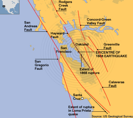
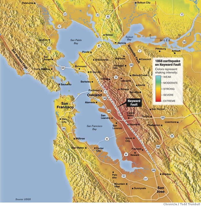
The Hayward Fault Zone is a geologic fault zone capable of generating significantly destructive earthquakes. This fault is about 74 mi (119 km) long,[1] situated mainly along the western base of the hills on the east side of San Francisco Bay. It runs through densely-populated areas, including the cities of Richmond, El Cerrito, Berkeley, Oakland, San Leandro, Hayward, Fremont, and San Jose.
The Hayward Fault is parallel to its more famous (and much longer) westerly neighbor, the San Andreas Fault, which lies offshore and through the San Francisco peninsula. To the east of the Hayward lies the Calaveras Fault. The Hayward Fault merges with the Calaveras Fault east of San Jose.
North of San Pablo Bay, and somewhat offset from the Hayward Fault is the Rodgers Creek Fault, considered by many[by whom?] to be an extension of the Hayward Fault Zone. Another fault further north, the Maacama Fault, is also considered to be part of the "Hayward Fault subsystem".[2][3]
While the San Andreas Fault is the principal transform boundary between the Pacific Plate and the North American Plate, the Hayward Fault takes up a share of the overall motion between the plates.
http://en.wikipedia.org/wiki/Hayward_Fault_Zone
The Maacama Fault is a right lateral-moving (dextral) geologic fault located in the Coast Ranges of northwestern California. It is considered to be the northernmost segment of the Hayward Fault subsystem of the San Andreas Fault zone. Creep along the Maacama is about 8 mm per year, consistent with the steady movement along the rest of the Hayward Fault system. It is also capable of producing large earthquakes.[1]
The Maacama Fault, is also considered to be part of the "Hayward Fault subsystem"
http://en.wikipedia.org/wiki/Maacama_Fault
KTVU And Wires
SACRAMENTO, Calif. —
A California Department of Transportation technician responsible for crucial seismic tests to ensure the safety of the new San Francisco-Oakland Bay Bridge span is under investigation in connection with testing for major transportation projects throughout the state, according to a published report Sunday.
The Sacramento Bee said it uncovered falsified safety tests by the technician, who has been put on administrative leave and whose previous work on a busy Los Angeles highway bridge, an Oakland freeway sign and other projects is now being probed by federal and state officials.
At a projected cost of $6.3 billion, the new eastern span of the Bay Bridge is the largest public works project in California history, and it is poised to open for public use in in 2013.
Engineers have repeatedly stressed the need to ensure bridge can withstand the strongest anticipated earthquake. The roadway of the existing span partially collapsed in the 1989 Loma Prieta earthquake during the World Series between the San Francisco Giants and the Oakland Athetics.
http://www.ktvu.com/news/news/local/report-questions-raised-bay-bridge-safety-test/nFcWn/